 eAtlas Data Catalogue
Geoscience Australia
Type of resources
Topics
Keywords
Contact for the resource
Provided by
Formats
Representation types
Update frequencies
status
Scale
-

The MARine Sediment (MARS) database contains detailed information on seabed sediment characteristics for samples collected from Australia's marine jurisdiction, including the Australian Antarctic Territory. It also includes the Geat Barrier Reef (GBR). It is an important scientific resource that includes survey and sample information such as locations, water depths and sample descriptions. Data are also provided from quantitative analyses of the sediments, such as grain size, mud, sand, gravel and carbonate concentrations, mineralogy, age determinations, geochemical properties, and physical attributes for down-core samples including bulk density, p-wave velocity, porosity and magnetic susceptibility. Images and graphics are presented, where available. MARS currently holds >40,000 sample and sub-sample records, and approximately 200,000 records describing the characteristics of these samples. New data are being added as they become available. It includes: Core, Dredge, Grab, Water, Column and Camera samples. Format: Data can be downloaded in CSV format for: - All sample data, - CaCO3 as mud/sand/gravel/bulk, - CaCO3 +grain size as mud/sand/gravel/[bulk|mean], - Grain size as mud/sand/gravel/mean, - Grain size for laser, - Grain size all, - Minerals with method of ICP-MS/XRF - Salinity. The full database is a 500 MB CSV. For the eAtlas the "CaCO3 +grain size as mud/sand/gravel/[bulk|mean]" CSV file was downloaded and converted to a shapefile for visualisation. This is available for download from this record. This metadata is not an authoritative source and was developed for the eAtlas. Please check or contact Geoscience Australia for authoritative metadata. The original data is available for download via the Marine Sediments (MARS) Database Search (http://www.ga.gov.au/oracle/mars/). The full database contains samples of the following type (this list is taken for data from 2010 - 2015): PROPERTY UOM Ag ppm Al mg/kg Al2O % Al2O3 w% Al2O3 % As ppm As mg/kg Authigenic-P umol/g Ba ppm Be ppm Bi ppm Ca mg/kg CaCO3 % CaO w% CaO % carbonate content % Cd ppm Cd mg/kg Ce ppm Chlorin index Chlorophyll a ug/g Chlorophyll b ug/g Chlorophyll c ug/g Cl ppm Co mg/kg Co ppm Cr mg/kg Cr ppm Cs ppm Cu mg/kg Cu ppm delta 13C o/oo delta 15N o/oo Detrital-P umol/g Dy ppm Er ppm Eu ppm Fe mg/kg Fe2O3 % Fe2O3TOT w% Ga ppm Ga mg/kg Gd ppm Ge ppm grain size % grain size um grain size No unit grain size m2/g Hf ppm Ho ppm K2O w% K2O % La ppm Lu ppm Mg mg/kg MgO w% MgO % MINERAL w% MLOI w% Mn mg/kg MnO w% MnO % Mo ppm Mo mg/kg Na2O w% Na2O % Nb ppm Nd ppm Ni mg/kg Ni ppm O2 mmol/m2/d Organic-P umol/g Oxide Associated-P umol/g P mg/kg P2O5 w% P2O5 % Pb ppm Pb mg/kg pH Phaeophytin ug/g porosity % Pr ppm Rb ppm S mg/kg salinity Sb ppm Sc ppm Sc % Se mg/kg SiO2 w% SiO2 % Sm ppm Sn ppm SO3 w% SO3 % SOD %/g/d specific surface area m2/g Sr ppm Ta ppm Tb ppm TCO2 mmol/m2/d Th ppm TiO2 w% TiO2 % TKN % TN % TOC % Total sediment metabolism umol/cm3/d Total sediment metabolism umol/g/d U ppm V mg/kg V ppm W ppm Water temperature degC Y ppm Yb ppm Zn mg/kg Zn ppm Zr ppm
-
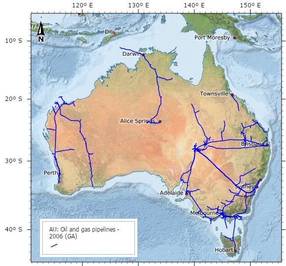
This data set contains information on Oil and Gas pipeline infrastructure. This dataset has been converted from Microstation format used in a map "Petroleum Exploration and Development Titles" published annually in APRIL. Attributes have been added to comply with data standards and minor coding of line work has been achieved using annotation from the map. Further data has been added, specifically for the specific Acreage Release Areas. This metadata was prepared for the North West Atlas and is not authoritative. Please contact the custodian for the latest authoritative version of this record.
-
Geoscience Australia has the primary role in the delineation of Australia's maritime boundaries. An output of this activity is the development of the Australian Maritime Boundaries (AMB) data. AMB is a GIS data product, replacing AMBIS 2001 Version 1.1, providing access to the data for Australia's Territorial Sea Baseline (TSB) and maritime zones. Note: This is a non authoritative copy of the metadata for the use in the eAtlas. Please refer to Geoscience Australia for queries on this dataset. This version of the dataset is now superseded by the Seas and Submerged Lands Act 1973 - epoch AMB2014a dataset. AMB is a digital representation of Australia's territorial sea baseline and boundaries as established under the Seas and Submerged Lands Act 1973. The data also include a representation of the limits by which the adjacent areas of each of the States and of the Northern Territory are determined under the Petroleum (Submerged Lands) Act 1967. In the event of an inconsistency between AMB data and the baseline and limits under the legislation, the latter prevails. The data have been published by Geoscience Australia in consultation with other relevant Commonwealth Government agencies including the Attorney-General's Department, the Department of Foreign Affairs and Trade and the Australian Hydrographic Office. AMB data comprise the TSB and the outer limits of each zone, together with maritime boundaries determined by treaties between Australia and neighbouring countries. Base points that generate the zone boundaries are supplied in separate files and an extensive user guide provides useful background information. All data coordinates are supplied in the World Geodetic System (WGS 84) (ITRF 2000 @ 2000.0) which is effectively identical to the GDA94 datum. Geoscience Australia is committed to the maintenance of the maritime boundaries data to ensure it reflects the changing nature of Australia's coastline and hence the various maritime zone limits. The data reflects the location of the coastline within the constraints of available source material at the time of production. Where major differences have since been discovered, these are listed in a table of notes and cautions. Note: This is a non authoritative copy of the metadata for the use in the eAtlas. Please refer to Geoscience Australia for queries on this dataset.